Last year we deployed some Hughes HL1120W OneWeb terminals in one of the remote cellular networks we support.
Unfortunately it was failing to meet our expectations in terms of performance and reliability – We were seeing multiple dropouts every few hours, for between 30 seconds and ~3 minutes at a time, and while our reseller was great, we weren’t really getting anywhere with Eutelsat in terms of understanding why it wasn’t working.
Luckily for us, Hughes (who manufacture the OneWeb terminals) have an unprotected API (*facepalm*) from which we can scrape all the information about what the terminal sees.
As that data is in an API we have to query, I knocked up a quick Python script to poll the API and convert the data from the API into Prometheus data so we could put it into Grafana and visualise what’s going on with the terminals and the constellation.
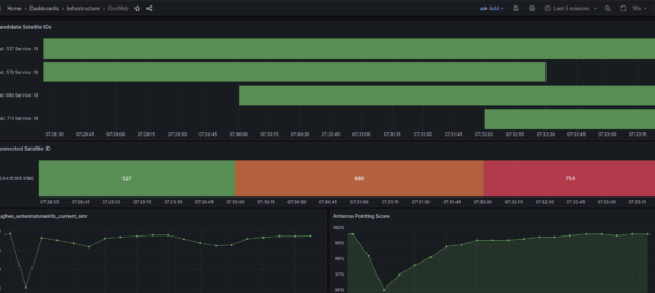
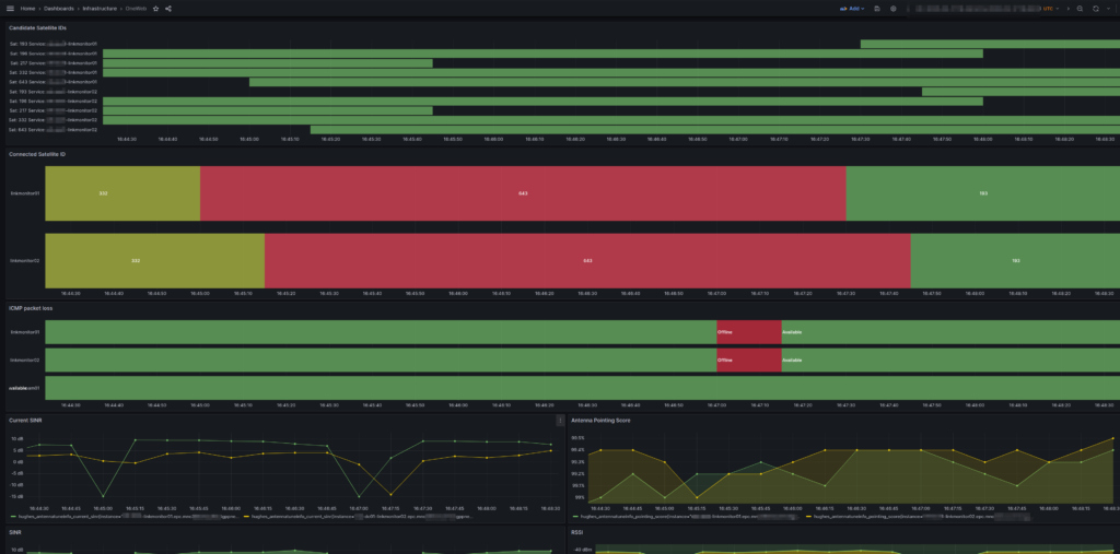
After getting all this into Grafana and combining it with the ICMP Blackbox exporter (we configured Blackbox to send HTTP requests and ICMP pings out of each of the different satellite terminals we had (a mix of OneWeb and others)) we could see a pattern emerging where certain “birds” (satellites) that passed overhead would come with packet loss and dropouts.
It was the same satellites each time that led to the drops, which allowed us to pinpoint to say when we see this satellite coming over the horizon, we know there’s going to be some packet loss.
In the end Eutelsat acknowledged they had two faulty satellites in the orbit we are using, hence seeing the dropouts, and they are currently working on resolving this (but that actually does require rockets, so we’re left without a usable service for the time being) but it was a fun problem to diagnose and a good chance to learn more about space.
I’ve put the source code for the Hughes terminal Prometheus Exporter onto Github for anyone to use.
The repo has instructions for use and the Grafana templates we used.
At one point I started playing with the OneWeb Ephemeris data so I could calculate the azimuth and elevation of each of the birds from our relative position, and work out distances and angles from the terminal. The maths was kinda fun, but oddly the datetimes in the OneWeb ephemeris data set seems to be about 10 years and 10 days behind the current datetime – Possibly this gives an insight into OneWeb’s two day outage at the start of the year due to their software not handling leap years.
Despite all these teething issues I’m still optimistic about OneWeb, Kupler and Qianfan (Thousand Sails) opening up the LEO market and covering more people in more places.
Update: Thanks to Scott via email who sent this:
One note, there’s a difference between GPS time and Unix time of about 10 years 5 days. This is due to a) the Unix epoch starting 1970-01-01 and the gps epoch starting 1980-01-05 and b) gps time is not adjusted for leap seconds, and ends up being offset by an integer number of seconds.
Update: clarkzjw has published an open source tool for visualizing the pass data https://github.com/clarkzjw/LEOViz